Mapping Conventions
Maps of Trid weren’t important until the Age of Fable, when the elves began to assess the size, shape, and populations of the Continent. As the Ardic Republic grew, the elves developed a full view of the land and sea—by direct exploration where possible or by divination where not.
Maps of Trid are laid out in a system of hex grids designed to zoom from world view to a single one-mile hex with no substantial loss in fidelity.
Hex Scale
Overland maps are laid out on grids based on one of three hex sizes:
| Hex Type | Hex Scale* | Hex Area | Contains |
|---|---|---|---|
| Atlas | 30 miles | 778.48 mi2 | 25 regional or 900 local hexes |
| Regional | 6 miles | 31.14 mi2 | 36 local hexes |
| Local | 1 mile | 0.86 mi2 | 1 local hex |
Map Templates
Overland maps are rendered on gridded hex templates, each based on one of the hex sizes above:
| Template | Hex Scale | Height | Dimensions | Area |
|---|---|---|---|---|
| Atlas | 30 miles | 30 atlas hx | 900 mi x 900 mi | 810,000 mi2 |
| Regional | 6 miles | 25 reg. hx | 150 mi x 150 mi | 22,500 mi2 |
| Local | 1 mile | 12 local hx | 10 mi x 12 mi | 120 mi2 |
Atlas Template: At 810,000 square miles, an atlas template a slightly smaller than Saudi Arabia and slightly bigger than Mexico. It would take about four-and-a-half atlas templates to map the continental United States. Each atlas template contains 36 regional maps.
Regional Template: At 22,500 square miles, each regional template has enough area to map Togo or Croatia; it would take two regional templates to contain the US state of Ohio, and just over four to map the United Kingdom. Most sandbox campaign maps are rendered on the regional template.
Local Template: Each local map is just a hair over 120 square miles, and about 188 fit inside a regional template. A local map is big enough to contain Montserrat, Anguilla, or two San Marinos. It would take two local templates to map the Cook Islands.
Coordinate System
The Trid world map is an equirectangular projection composed of 200 Atlas maps laid out on a 20 x 10 grid (which does a poor job of representing the planet’s curvature but eases the task of laying out Cartesian coordinates).
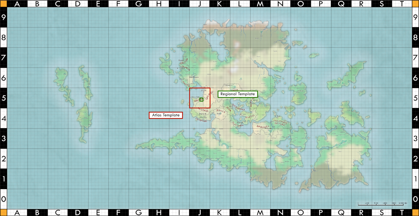
Each large square on the world map map above is a single atlas template; small squares are regional templates within. Using these templates allow us to designate locations with a simple coordinate system that starts with the atlas map, the regional map within it, then a specific hex.
The map above shows the atlas map “J5” highlighted in red and, within it, the regional map “D3” highlighted in green. This location is noted as “J5D3”. Each individual hex on a regional or local map is assigned a 4-digit number (e.g., “1216”), and we can append these in sequence to get the location of a single local hex, like “J5D3-1216-0910.”
Locations smaller than one mile across are rendered on square grids with scales of 1/4 mile, 100 yards, 100 feet, or 50 feet per square. Encounter maps are more detailed and rendered on square grids measuring 10 or five feet per square.
Mapping Software
The majority of Trid’s maps are created with the following tools:
- World / overland maps: Azgaar’s Fantasy Map Generator
- Hex maps: Worldographer
- City, Village, and Dungeon maps: Watabou’s Procgen Arcana
All post-production work is done in Affinity Designer.