Terrain
Terrain Distribution & Population
Trid has a global land area of 34.2 million square miles, with a total population of 33.9 million, for a rough global population density of one person per square mile. However, not all land is equally habitable, and the table below shows the population by terrain type.
| Terrain | Area (sq. miles) | Population | Population Density |
|---|---|---|---|
| Barrens/Hills/Mountains | 2,800,000 | 230,000 | 0.08/sq. mile |
| Clear/Grasslands | 8,800,000 | 5,100,000 | 0.58/sq. mile |
| Desert | 636,000 | 122,000 | 0.19/sq. mile |
| Forest | 9,800,000 | 17,300,000 | 1.77/sq. mile |
| Jungle | 2,000,000 | 3,500,000 | 1.75/sq. mile |
| Swamp | 3,500,000 | 4,800,000 | 1.37/sq. mile |
| Taiga (cold forest) | 6,200,000 | 2,500,000 | 0.40/sq. mile |
| Tundra (cold clear) | 804,000 | 207,000 | 0.26/sq. mile |
| Totals: | 34,540,000 | 33,759,000 | 0.98/sq. mile |
Terrain Types
Trid uses the same terrain types described in the classic rules. These are described below, along with their hex map symbols.
Barrens / Hills / Mountains
Any rough terrain with sparse vegetation.
| Terrain | Description | Icon |
|---|---|---|
| Barrens | Dry and bare land covered with a mix of rock and soil; sometimes referred to as rocky deserts. |  |
| Glacier | Thick sheets of hard-packed ice and snow that move slowly under their own weight; typified by wide snowfields, crevasses, steep inclines, and ice caves. |  |
| Hills | Rocky and uneven heights, often with caves, canyons, and plateaus, usually ringing mountain ranges. |  |
| Mountains | Essentially hills rising above 1,000 feet. Altitude makes mountains colder by one climate band (e.g., a sub-tropical mountain range has a temperate climate). |  |
City
In the context of terrain, “city” refers to any settlement. Certainly, this includes cities, towns, and villages, but also strongholds, monasteries, and fighting orders.
| Type | Population | Icon |
|---|---|---|
| Village | 50–1,000 (1d20 x 50) |  |
| Town, small | 500–5,000 (1d10 x 500) |  |
| Town, large | 4,000–15,000 (1d12+3 x 1,000) |  |
| City | 13,000–24,000 (1d12+12 x 1,000) |  |
Port: Any settlement that engages in trade via river or sea. Port settlements support an additional population of 20–50% (1d4+1), consisting of dock labour and security, merchants, trade guilds, and travellers.
Capital: Any settlement that serves as the seat of government in an established polity. Capitals may be formed of any settlement type and are outlined in red on the map. These urban centres support an additional population of 30–80% (1d6+2), consisting of bureaucrats, noble families, diplomats, security, merchants, and travellers.
Clear / Grassland
Generally flat land covered with abundant, low-lying vegetation.
| Terrain | Description | Icon |
|---|---|---|
| Clear | Typically lightly wooded land and relatively easy to convert to arable acreage. |  |
| Grasslands | Characterised by short shrubs, tall grass, and the occasional stand of trees. As with clear terrain, soil is rich and fed by plentiful sources of water. |  |
| Tundra | Clear terrain in cold areas with low grasses and hearty shrubs. |  |
Desert
Arid regions that receive little to no annual rainfall. Plants and animals survive in deserts through specialised adaptations, adding to the danger of this desolate terrain.
| Terrain | Description | Icon |
|---|---|---|
| Cold Desert | High-altitude desert with rocky soil. |  |
| Hot Desert | Usually sand-filled with dunes formed by wind; the occasional oasis exists where fed by a natural spring. |  |
Forest
Any predominantly wooded area where trees provide a tall canopy.
| Terrain | Description | Icon |
|---|---|---|
| Forest | Deciduous trees that can withstand the extremes of hot summers and freezing winters. Undergrowth may be sparse if a dense canopy prevents sunlight from reaching the ground. |  |
| Taiga | Cold forests dominated by conifers extending to the treeline at the arctic climate band. |  |
Jungle
Limited to tropical climes, jungles are “multi-story” forests, with tall and medium-height trees whose canopies are thin enough to allow thick undergrowth.
| Terrain | Description | Icon |
|---|---|---|
| Jungle | Generally thick undergrowth and tall trees that provide the basis for a vibrant and intimately connected ecosystem. Jungles are hot, humid, and teeming with predators. |  |
Lake / River
Bodies of fresh water.
| Terrain | Description | Icon |
|---|---|---|
| Lake | A standing body of fresh water; lakes may be of any size, depth, or altitude. They are often fed and/or drained by rivers. |  |
| River | A flowing course of fresh water; rivers may be of any length, width, or current speed. Generally, rivers start in higher altitudes with swift and narrow currents that slow down over distance, invariably flowing into another body of water (i.e., another river, a lake, or the sea). |  |
Ocean / Sea
Bodies of salt water.
| Terrain | Description | Icon |
|---|---|---|
| Ocean | Vast stretches of open water, separating continents. |  |
| Sea | A smaller part of an ocean, partially enclosed by land. |  |
Settled
Land surrounding an established settlement, made safe by armed patrols and satellite occupants (homesteads, industrial centres, etc.). The larger the settlement, the larger the area of settled terrain around it:
| Type | Sphere of Influence | Radius |
|---|---|---|
| Village | Current Local hex (0.86 mi2) | 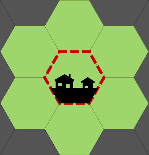 |
| Town, small | Current Local hex + 1 Local hex radius (6 mi2) | 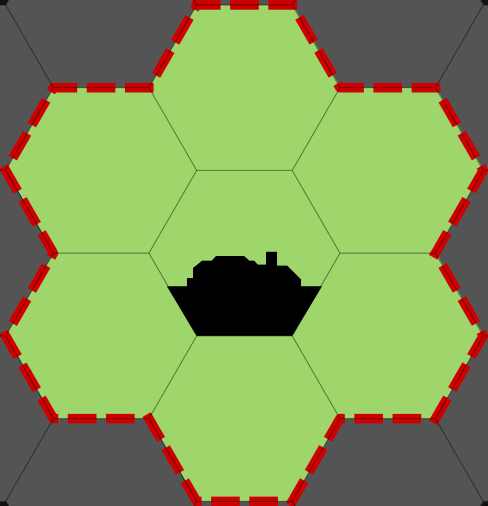 |
| Town, large | Current Regional hex (31.14 mi2) | 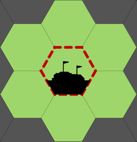 |
| City | Current Regional Hex + 1 Regional hex radius (218 mi2) | 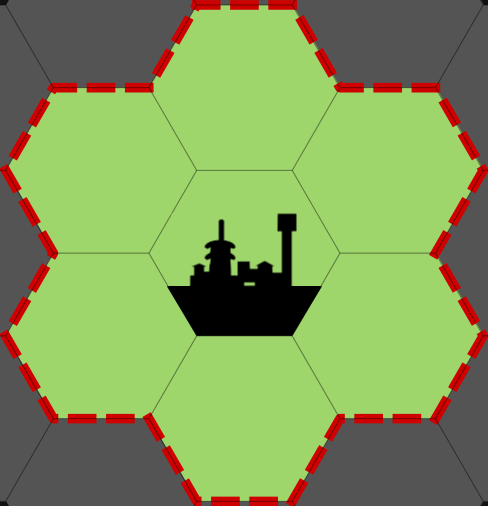 |
Swamp
Any wetland area where poor drainage allows standing water.
| Terrain | Description | Icon |
|---|---|---|
| Swamp | Wooded wetland, though other wetlands may be represented: * Marsh (shallow wetlands dominated by low vegetation and grasses) * Bog (acidic wetlands fed by rainwater, rich with decomposing vegetation * Fen (alkaline wetlands, usually fed by underground springs) |  |